Black Creek dye trace
Black Creek Tracer Test: Success!
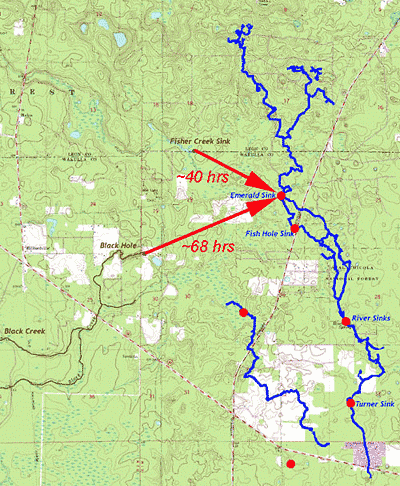
The Black Creek tracing study has been a great success. After three long days of field prep and overcoming unforeseen obstacles, we injected ~3kg of Uranine into Black Hole (the primary insurgence of Black Creek) at 10:00 PM Friday night. At approximately 6:00 PM Monday evening we recorded the dye as it passed the sampling tube in the dark water tunnel ~700 feet down stream of Emerald Sink in the Leon Sinks cave system. That is the same point at which we confirmed the Fisher Creek connection earlier this year. We now know that the two flows merge somewhere upstream of that point and both connect directly to the Leon Sinks cave system. Since we were set up to catch the dye at several points further down stream in the cave system, we have now successfully measured break-through curves at Fish Hole and Upper River Sink and expect to see one at Turner Sink as well, once all the samples are run. We have also set up a sampler at Wakulla Spring that we'll try to keep running for another week in case the tracer comes through there at a detectable level.
The additional break-through curves from sequential points downstream of Emerald have provided an unexpected bonus that will allow us to learn a great deal more about the flow parameters through the cave system. It will also provide an excellent base from which we can plan future traces including the Ames Sink traces which are scheduled to begin early next year and potentially a trace from Leon Sinks to Spring Creek and Wakulla Springs.
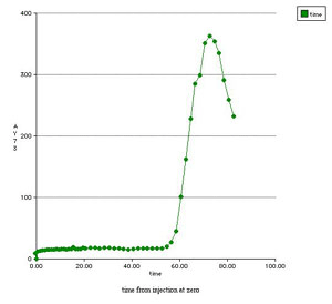
Partial break-through curve in the dark water tunnel ~700 ft downstream of Emerald Sink
Significance
The results of the Black Creek and Fisher Creek tests offer
significant insight to the hydrology of the Woodville Karst Plain and to
the question of increasing number of dark water days at Wakulla
Spring. From these results, it now appears that all of the surface
drainage that disappears underground, quickly converges on the Leon
Sinks cave system, and then flows downstream to either Spring Creek
or Wakulla, or most likely, both depending on the flow stage.
Increasing surface water runoff created by expanding impervious
surfaces could therefore be a significant cause of the increasing
number of dark water days at Wakulla as that would contribute to
maintaining higher than average flow stages in the streams and
thereby elevated surface water:groundwater ratios in the spring
discharges. We'll be continuing to test this hypothesis with the
forthcoming Ames Sink tracer tests.
Future Work
We'll be publishing a final report on the Fisher Creek and Black Creek tracer tests with the Florida Geological Survey later this year. Next year's agenda will focus on delineating the flow path(s) between Ames Sink and Wakulla Spring . To accomplish that task, we'll be launching a series of focused tracer tests between various points north of Wakulla Spring and east of the Leon Sinks cave system designed to systematically characterize the flow paths northward from Wakulla Spring. GUE and the WKPP will again be instrumental in the success of the project through their participation in identifying and instrumenting key sinkholes and conduits adjacent to and within the Leon Sinks cave system. GUE and the WKPP are also initiating an effort to re-map the section of the Leon Sinks cave system between Turner and Emerald Sinks with a special focus on identifying dark water tunnels. Ultimately, the goal of these efforts is to develop a comprehensive model of groundwater flow and groundwater/surface water flow interactions within the Woodville Karst Plain that will identify the key variables crucial to developing a sustainable protection plan for Wakulla Spring and more broadly, the groundwater resources in Leon and Wakulla Counties.
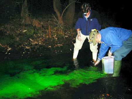
Uranine Injection at Black Hole, 10:00 PM Friday
Initial funding for this effort will again be provided by the Florida Geological Survey Hydrogeology Program with additional support coming now from the Florida Department of Environmental Protection's Springs Initiative Program and Wakulla Springs State Park. In order to see the project through to completion, however, we will need to find additional funding especially for the longer tracing and model development components of the project.
Acknowledgements
Funding for this project was provided by the Florida Geological Survey Hydrogeology Program. Enormous thanks go out to everyone that helped us pull the experiment together. In particular, I want to thank the following: Nick Wooten and the Northwest Florida Water Management District for lending us the autosamplers; James McClean at the FGS for putting in the long hours and continuing the work through the weekend; Bjarne Knudsen and Casey McKinlay of the WKPP for installing sampling tubes in the caves; Wakulla Springs State Park for providing convenient accommodations; Dave Turner and Anthony Santelli of WRS Infrastructure and Environment Inc. for supplying needed pumps in a pinch; and Cal Jamison, Sarah Cervone, Linda Jamison, Dawn Kernagis, Stacey Sandrey, Sherry Provo at the USFS Apalachicola District, John Glunn, Dale Schroeder, Marvin McKenzie, Mr. Corbett, and Mr. and Mrs. Stafford for volunteering or arranging the necessary access to the sinkholes.